FRONTS
A SERIES ON WEATHER
WHAT TO EXPECT OUT THERE!
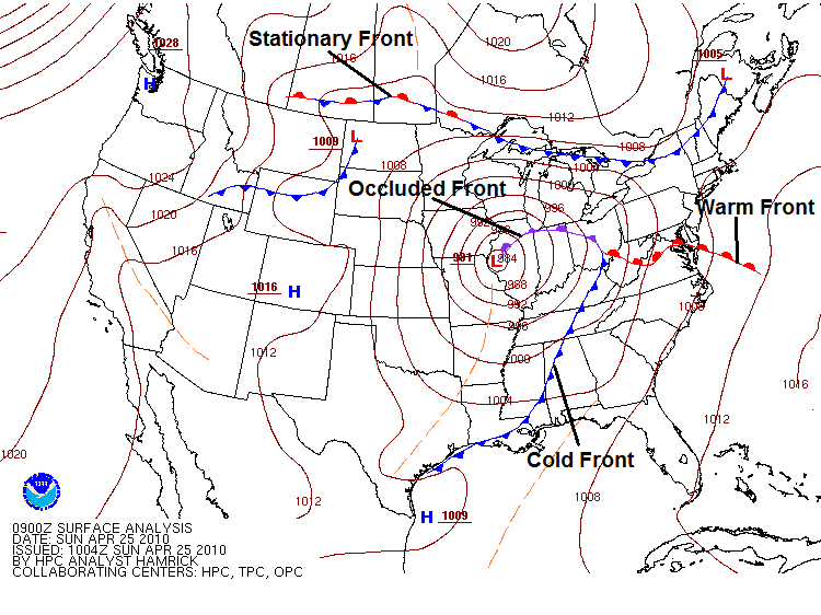
I begin this series on the basics of WEATHER. What causes different weather patterns, what should we expect to see on any flight based on what we see in the weather charts. This is a typical weather depiction map of fronts that we will see during our flying careers! All four types of fronts are displayed here.
What is a Front? A Transition Zone of separate air masses of differing characteristics. It is the leading edge (the Front) of a change in temperature, for example a “Cold Front” is the leading edge of an Air Mass with cooler temperatures compared to air mass in front that it’s replacing. What other indications do we see in a frontal movement or frontal passage, also known as a FROPA? We will see the direction of the wind change, often as much as 180 degrees; we will also see a rise or possibly a fall in air pressure. For example in a “Cold FROPA” we will see the winds change from a Southerly flow to a Northerly flow. A drop in air temperature and a fall followed by a rise in Atmospheric Pressure. Each type of front has its own characteristics of weather that we will expect to see while flying.
There are four types of Fronts you might run into and each front has predictable types of weather, and most importantly how to plan for, these fronts.
COLD FRONT
Perhaps the easiest to forecast and see coming our way as pilots. This front is the fastest moving of all the fronts and has the most change in conditions over time. It is characterized as a wedge of cold air, that under-rides warmer air that it will replace. This is where warm air, coming from the South and contains moisture, is met by cold air, which is fast moving, associated with a LOW PRESSURE center, and is coming from the North or Northwest. Where they meet (at what altitude-depends on the rate of slope) will cause strong weather that is often not a good area for an aircraft.
WARM FRONT:
Is a Slow-moving area like a blob of warm air, usually associated with the backside of a HIGH Pressure area, starting to break down and give way to colder air. Characterized by still air often moist, hazy skies, light to no wind. The warm air overrides the cooler air, causing precipitation starting with light rain increasing in intensity as the front nears. In the summer months the air becomes stagnant and can be called Smog (poor air quality) and hang around for days. It is almost always replace by a COLD FROPA, and clearing air.
STATIONARY FRONT:
Is called Stationary because it does not move very fast, if at all! It is a combination of both warm and cold air and can sit across a large area of real estate for days. When this happens, the weather typically is a lot of rain, foggy visibility, light winds and low ceilings. Basically, crummy weather and often held in place along the eastern edge of the Rocky Mountains, or along the Gulf Coast and Texas. Sooner or later a Cold Front will come along and “clear the air”. We see stationary fronts during the summer months that can also cause poor air quality.
OCCLUDED FRONT:
An OCCLUSION is a combination of a Cold Front (without much push), and a warm front sitting in front of the cooler air, and a Stationary Front (just sitting in place). Weather conditions are very much like the Stationary Front, depending on what side of the front you are in. An Occlusion is centered around a Low-Pressure area that is not moving. Aloft we can see steady rain, lots of clouds at all levels, rain showers and thunder storms, and probably fog on the ground, not a good day for a cookout!
SQUALL LINES: Also known as a, Pre-Cold-Frontal Squall line. Unstable air ahead of and running parallel to a cold front, will build strong thunderstorms, often between 50 to 150 miles in advance the cold front. A squall can pull much of the moisture out the cold front, and weaken it; but I have also seen this line of heavy weather, build to high altitude, catch the winds in the Jet Stream. When this occurs it will pull the cold front with it and get the front moving. Either way, this weather is no place for your aircraft!
Pressure Systems: There is either a High-Pressure System or a LOW-Pressure System. When looking at weather maps, we are always looking down at the weather system. HIGH Pressure systems are associated with good weather: clear skies, light winds, good visibility. They are said to flow; Clockwise with an Anti-Cyclonic rotation, the winds flow out of the center. Low Pressure systems are the opposite, Cyclonic flow and Counter Clockwise rotation, the winds flow into the center, usually means bad weather. More on pressure in the next of our series.
Fly Safely Check the Weather Know what to expect File Flight plan
Until next month,
Captain Will Rondeau
References
Weather Elements, a text in elementary meteorology. Blair/Fite.
FAA Pilot’s Handbook of Aeronautical Knowledge, FAA-H-8083-25B. Chapters 12 and 13.


